
Another wave splashed over the bow of the canoe, hitting me in the face as my dad and I paddled straight into a headwind on Knife Lake while paddling in the BWCA. It was one of those days where you normally would just stay in camp and not paddle, but I was due back at work the next day.
Yes, one of the very things that we go to the wilderness to escape was causing me to struggle across this huge lake.
I closed my eyes and paddled hard. “One…two…three…four…” I counted each stroke until I got to 100 then opened my eyes again. The shore didn’t seem an inch closer. In fact, it almost seemed farther away!
I gritted my teeth and began to fantasize about that wonderful portage at the end of the lake.
Yes, I used the words “wonderful” and “portage” in the same sentence.
I admit – I love portages! It’s not just on those windy days, either. Most of my time in the wilderness tends to be on foot as I am more of a backpacker than a canoeist. Don’t get me wrong, I love to paddle, I truly do, but there is just something wonderful about mucking around the bush on your own two feet.
Like many Minnesotans, my first experience in the “backcountry” was when I discovered the Superior Hiking Trail, an amazing footpath which weaves its way among the Sawtooth Mountains of Lake Superior’s North Shore. With over 300 miles of sweeping mountaintop vistas, cascading rivers and endless forests, I could probably hike it for the rest of my life and never tire of it.
However, every person who likes testing themselves in the outdoors needs to raise the bar every now and then. After completing the entire Superior Hiking Trail (what was done at that time) in 1998, I looked for a new challenge. I decided to explore some of the trails in Minnesota’s only true wilderness: the BWCA.
First on my list was the Kekekabic trail.
“The Kekekabic Trail is one of the toughest, meanest rabbit tracks in North America … It is the kind of trail that would break the heart of a man who didn’t have what it takes to go into the wilderness and try to ‘smooth it.’” Those words were written by Whitney Evans on a Boy Scout trip in 1949. 50 years after they were written, I wanted to see if I had “what it takes.”
Unfortunately, 1999 was the year of the epic Fourth of July windstorm that decimated much of the BWCA. In that mostly pre-internet era, I failed to do enough research, but figured three months was enough time to get the trail cleared.
We set off. My companions and I hiked straight into the heart of the blowdown and straight back out with our trails between our legs and a hernia to show for it.
And so began my introduction to the trails of the BWCA. It quickly became a torrid love affair.
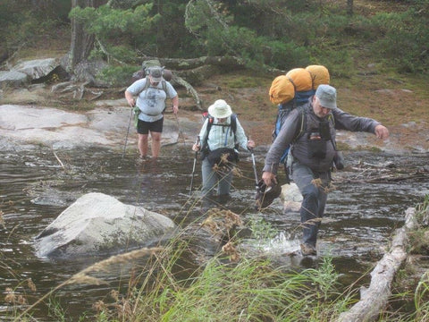
The hiking trails of the Boundary Waters are NOT like your typical state park trail or even the Superior Hiking Trail. They are the real deal. In many places you are barely able to tell there is a trail at all. You can’t just let your mind wander and hike on cruise control. You have to pay attention to where you are, otherwise you might find yourself turned around, confused and scrambling to retrace your steps.
You can also leave trail luxuries like bridges and puncheon behind for the most part. You might find yourself rock hopping, balancing atop beaver dams or wading through deep water. Plus, most of the trails in the BWCA have no escape route. Cell service is virtually nonexistant and unlike the Superior Hiking Trail, where there is a trailhead every ten miles or so, once you’re in, you’re in. You are committed to either make it to the end of the trail or go back to where you started.
That’s what I love about hiking in the Boundary Waters.
It’s raw and real and trekking there has a real sense of danger. In many cases, the distance just getting to most trailheads can be quite the expedition. Once you’re just a few yards down the trail, all you will hear is the sounds of the wild: Birds and squirrels, the wind and the rain, the wolves and the loons. And running into any other hikers? It’s very rare indeed. You’re more likely to cross paths with someone hauling a canoe over a portage than another hiker. Even that is pretty unlikely.
I think my last canoe trip in the Boundary Waters was in 2002. Since then I have backpacked the Kekekabic twice and the Border Route, Angleworm and Sioux-Hustler trails. I’ve day hiked to the summit of Eagle Mountain a half dozen times and have winter camped on Hegman Lake three times, hiking to its pictographs a half dozen times as well. This last Memorial Day weekend I went on a dayhike on the Powwow Trail. I can’t wait for volunteers to clear it so I can backpack its length.
Sometimes I wonder why I spend so much time in a place called a “Canoe Area Wilderness” on foot. It’s not that I don’t enjoy canoeing — I love it! But on foot, it just seems like you can get a little deeper into places few have ever seen. You still get to enjoy the beautiful lakes as most campsites are nestled beside them and I challenge you to find a more spectacular spot in the Boundary Waters the high upon the cliffs of the Border Route.
For those of you who are curious, below is a guide to a few of the most popular routes in the Boundary Waters. Think of it as an appetizer for future adventures. Hopefully you’ll be inspired to lace up your boots, load a pack and venture into the wilderness to find out if you have “what it takes.”